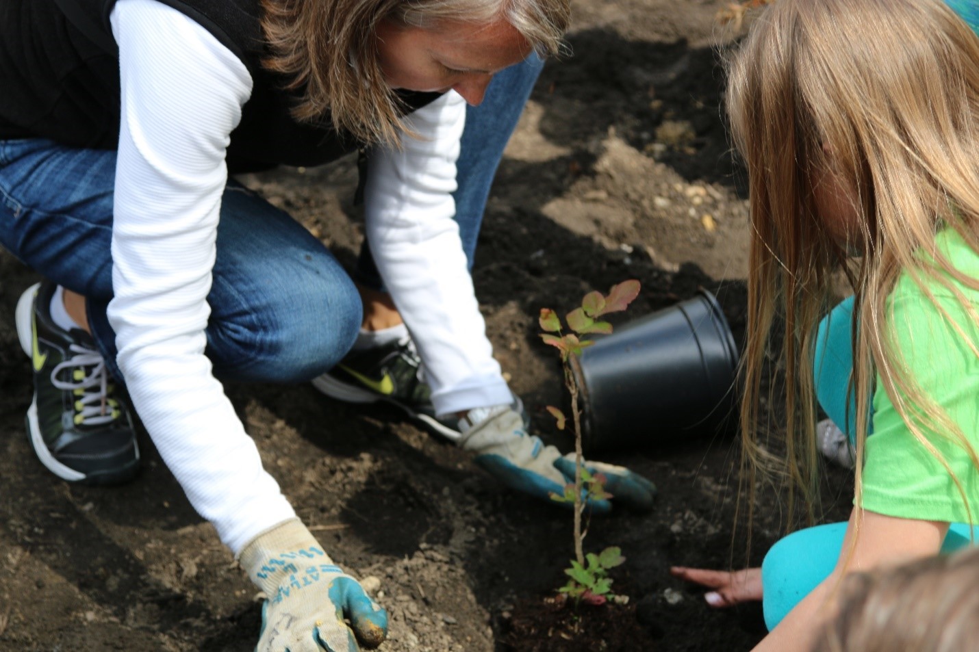

Volunteers plant trees and shrubs at East Lake Sammamish Trail on Earth Day in 2015.
Trails and non-motorized paths weave our communities together, improve livability, and promote healthy lifestyles. Parametrix employee-owners are passionate about designing safe spaces for people that offer a seamless connection to places where they live, work, and play. This Earth Day, get outdoors and celebrate by enjoying one of these trails!
East Lake Sammamish Trail North Sammamish Segment
Sammamish and Redmond, WA

The East Lake Sammamish Trail is an 11-mile urban trail connecting downtown Issaquah and Redmond via the east side of Lake Sammamish. Parametrix has worked in partnership with King County Parks on this project since 1999, providing planning, environmental documentation, design, permitting, and construction support services. The County is constructing the trail in segments with four segments complete and two currently in construction.
One of the completed segments trail users can enjoy now is the North Sammamish segment – this 2.6-mile part of the trail takes walkers and cyclists between Inglewood Hill Road at the south end to 187th Ave NE at the north end. This segment is a flat, 12-foot-wide paved surface with two-foot gravel shoulders on each side, providing the highest degree of accessibility to people of all ages and abilities.
The trail’s 41 new retaining walls provide slope stability and reduce the trail footprint, which means less impact on environmentally sensitive areas and adjacent residents. There are also five new fish passable culverts which improve water quality, enhance habitat, and increase access to spawning grounds for the Lake Sammamish Kokanee, approximately 1,150 new native trees and more than 11,000 shrubs, and almost two acres of wetland mitigation area restored to increase fish and wildlife habitat and improve biological diversity. This segment of the trail was completed in July 2015.
To enjoy this trail, cyclists or walkers could start at the south end of the segment and end at Marymoor Park for a snack before continuing on or turning back
Multi-Use Pathway at Dona Larsen Park
Boise, ID

This multi-use path, constructed in 2019, winds through Boise State University’s Dona Larsen Park in Downtown Boise. It extends from Warm Springs Avenue to Broadway Avenue, allowing users to avoid a busy intersection to get between neighborhoods, restaurants, the Boise River, and the greenbelt. This park is also the new home of Boise State’s track and field and softball programs. Come see the path on your way to enjoy some local sports!
Parametrix provided concept through final design for a segment of the pathway.
Mica Peak Trail
Spokane, WA

The Mica Peak Trail is located within the 1,794-acre Mica Peak Conservation Area managed by Spokane County. The mountainous area is located on the west slopes of Mica Peak at 5,200-feet elevation. The new 8-foot-wide trail was designed to replace a heavily eroded segment of trail.
Parametrix coordinated with Spokane County Parks, Recreation, and Golf to establish an alignment and provide construction documents. The team evaluated potential route alternatives based on topography and sensitive vegetation.
Plan a day trip to Mica Peak Conservation Area for hiking, mountain biking, horseback riding, or wildlife viewing.
United States Bike Routes
Statewide, UT

Utah currently has nearly 1,200 miles of US Bike routes crisscrossing the state. Together, these routes create a network that stretches north to south from Idaho to Arizona and east to west from Colorado to Nevada. Recently the Utah Department of Transportation adopted over 500 miles of these routes, creating the main north-south connection and several alternate routes.

Parametrix has assisted the Utah Department of Transportation with the adoption of these new routes and continues to help plan and identify improvements along them.

Where to start? One of the highlights of the route is the 100-mile stretch of continuous pathways along the Wasatch Front known as the Golden Spoke, climbing to more than 8,300 feet into Fish Lake National Forest, and scenic vistas in Southern Utah’s red rock country.
Alameda Drain Trail
Albuquerque, NM

The Alameda Drain Trail is a continuous 12-foot-wide, two-mile round trip multi-purpose path that runs along Alameda Drain in unincorporated Bernalillo County and Albuquerque, New Mexico. The Alameda Drain corridor extends from Interstate 40 on the south to the Sandia Pueblo boundary on the north, for an overall length of approximately nine miles.
Parametrix provided overall project management for the Alameda Drain & Trail Master Plan as well as transportation engineering for elements of the trail planning. The master plan is the result of a collaborative four party agreement between Bernalillo County, the Middle Rio Grande Conservancy District, the City of Albuquerque, and the Albuquerque Metropolitan Flood Control Authority.
The Alameda Drain was constructed to lower and moderate shallow groundwater tables and return unused irrigation water back to the Rio Grande for reuse. The drain is part of the larger network of water conveyances that shape development patterns in the Middle Rio Grande Valley.

The trail provides the multipurpose use of returning unused irrigation back to the Rio Grande as well as a path for bikers to enjoy. The shared use path works in conjunction with the drain, which results in a more cohesive, aesthetic corridor. Stormwater best management practices were incorporated into the design of the trail to improve water quality. The landscaping was designed to filter stormwater, create shade for trail users, and stabilize the drain and surrounding area. Various plants, trees, grasses, and shrubs were strategically placed in and around the Alameda Drain.
Salmonberry Trail
Tillamook, OR

This trail isn’t quite ready to visit this Earth Day, but something to look forward to in the future!
The Salmonberry Trail is a proposed 87-mile signature trail that follows the Port of Tillamook Bay Railway. Once built, the route will connect the Willamette Valley to the Oregon Coast, meaning trail users will pass by a series of different ecosystems, including the Oregon coastline, fisheries, farmland, and the Coast Range mountains. Parametrix provided trail inventories, concepts, costing, GIS, planning, and public involvement for all four trail segment plans over the last five years.
The trail features four unique segments – Coast, Valley, Canyon, and River. The Salmonberry Trail Project Team finalized the planning work for the 18.6-mile Canyon Segment and 15.3-mile River Segment in early 2021.

The first half mile of the trail is now open to the public in Tillamook. The rest of the trail is still in the planning stages. Please note that parts of the line are actively used by trains and the portions that have been storm-damaged are too dangerous for public access.